Denver shows how Esri GIS and Accela’s licensing tools are accelerating cannabis license processing and transparency.
For government, geography has an implicit connection to decision making. Geography directs how we navigate our streets, determines food choices, influences home prices, employment options, utilities and even the access we have to quality health care. With so much riding on location, maps have become a staple of government as agencies hunt for quick insights and competent solutions.
Now, the public sector’s capacity for cartography is gaining new ground through the spread of legalized cannabis. There are 30 states and Washington, D.C., that have legalized medical marijuana, eight of these have approved it for recreational use and still more are considering legalization in some form.
Mounting pressure to regulate the market has stirred the public sector to map cannabis distribution in same way it has leveraged mapping for transit planning, public safety, election boundaries and other services. The aim is to produce a new set of GIS data and digital visualizations tools that inform policy makers, residents and businesses.
Trailblazing in Denver
The city and county of Denver is a pioneer in these first efforts. Colorado voters legalized medical marijuana in 2000 and recreational marijuana in 2012. Since then, Denver officials have searched for the best strategies and tools to manage the numerous tasks associated with licensing and enforcement.
Eric Escudero, director of communications at the Denver Department of Excise and Licenses, said GIS data has acted as a key ingredient in the city’s licensing procedures. Using Accela, and tools from the GIS mapping company Esri, Escudero said Denver ensured cannabis business applicants never operate near prohibited locations like schools.
Essentially, each time Denver receives a business application to distribute marijuana, the city’s GIS verifies that an applicant’s facility isn’t in a prohibited area. This eases strain on staff, that would likely have to spend untold hours verifying addresses.
“Accela set up an interface between Accela’s cannabis record management system and the Denver address database and the Denver Accessor’s database,” Escudero said. “When a new record in Accela is created, it verifies the [geographic] coordinates of the validated address, identifies the associated [property] parcel, and stores that data in such a way that we can use it as a GIS layer.”
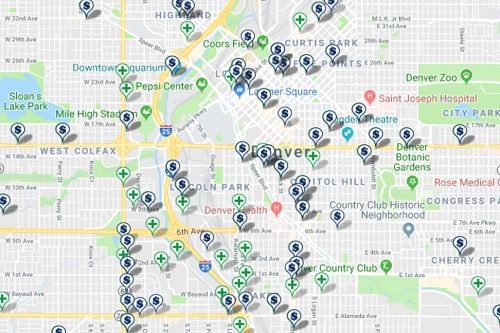
Cannabis GIS also increases transparency. Denver publishes their cannabis license data for the public in a digital map, and through its open data portal. Residents get the location of active licenses for both medical and recreational marijuana.
While new, Escudero said the application of GIS mapping for cannabis regulation isn’t necessarily novel. Instead, Escudero described it as a natural offshoot of the city and county’s mapping services. As examples, Escudero pointed to Denver’s use of GIS mapping for sewer flood planning, property records and building permits.
“GIS mapping fills a key need for Denver in many different capacities,” Escudero observed.
Yet Escudero advised localities that might be considering GIS for cannabis applications and management to remember that effective technology must be paired with effective and established procedures. He said a system should have the ability to provide enough detail to answer some of the more nuanced code enforcement questions.
For instance, if a city code asks for measurements of a building’s parcel line, that has to be part of the GIS layer, or if law requires a buffer between a school and a dispensary — then a GIS layer must include a parcel line measurement capability.
“Create a method to validate addresses and be clear on your measurement and methodology,” Escudero said. “Ensure the platform you’re using is capable of handling whatever methodologies you need to employ.”
Future Benefits of Cannabis GIS
Outside Denver’s work, Accela Solution Consultant Carl Figueiredo stressed that there are a host of other immediate advantages found in cannabis GIS data. By integrating Accela’s cannabis record management features with GIS services, provided by mapping services like Esri, code enforcement officers can spot hot spots where violations are happening, staff can automate clerical work in the licensing process and inspectors can report in the field. The only expectation on agencies is that they ensure their property data well attributed and prepared in a standardized format.
“What Accela is, is a system of records. All of the transactions that relate to things like cannabis licensing, enforcement, applications, all of it, is happening within our systems.” Figueiredo said. “We have all this data and you can pull it out of our system and then plug that into whatever, this could be reports, tables or maps.”
With many city staff already strapped for time and with limited resources, Figueiredo said automation is likely one of the biggest wins. Across the U.S. policy makers are proposing and amending cannabis regulations that can increase or alter implementation work for agencies. To meet this challenge, having an adaptable licensing system and structured GIS tools can be critical.
“We can actually build business rules into the application,” Figueiredo said. “So, for example, if I were to apply online for a dispensary, and my proposed address for the dispensary was too close to a school, say within a thousand feet of a high school, the system would automatically check for that and provide a notification that says, ‘Sorry this is not a permitted use.’”
Further, Figueiredo adds that agencies can also depend on cannabis GIS to help track enforcement trends, dispatching inspectors and enforcement officers to neighborhoods where there is a disproportionate number of code violations. On site, the officers could use Accela’s integrated mobile apps to share location-based inspection data, photos and documents with their home office.
“The ability to visualize where open enforcement cases are happening in space and leverage mapping to not only visualize this information, but also color a map dynamically based on status can be extremely valuable.” Figueiredo said. “This helps when you’re trying to see the lay of the land and figure out connections to other elements in a city.”
Learn more about Accela’s Cannabis Regulation for Local Government here, and for greater details on cannabis GIS, visit our industry experts at the Esri User Conference, GIS — Inspiring What’s Next, on July 9 – 13, 2018 at the San Diego Convention Center, in San Diego, California. Find our team in the Expo area at booth 919.